Wednesday, April 26, 2006

BACTERIAL INFECTION


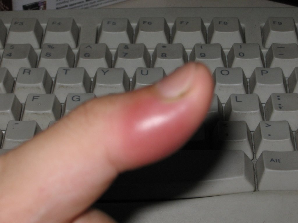
Currently, my left hand thumb have been in pain and swollen condition since Sunday, 23 April 2006 as I was diagnosed with bacterial infection. It is quite painful if I press my left thumb or I bend my lef thumb 90 degrees. I was given an Antibiotic injection on my buttock on Monday, 24 April 2006 to prevent the infection from spreading. At this moment, I am still on Antibiotic and pain medication for 1 week. My next appointment will be on 8 May 2006. Cycling is totally a no no for me as it will be very painful for my sollen left thumb if I were to hold the handle bar of the bicycle tightly. I can only go for running or hiking at this moment unless my left thumb is totally cured.

23 APRIL 2006

Location: TTDI Park
Time: 6.00 a.m.
Activity: Run from TTDI Park to Petronas Station in Sri Hartamas and ran back to TTDI Park with Wan Lin
Distance: Approximately 13 km
Timing: 1 hr 17 min 32.07 sec

Initially we plan to go to Desa Sri Hartamas (additional 3 km) but had to rush back as Wan Lin had class to attend at 9.00 a.m.

Tuesday, April 25, 2006

22 APRIL 2006

Activity: Run from TTDI Park to the hill (outside the park) and back to TTDI Park
Time: 7.30 p.m.
Date: 22/4/2006
Distance: 6.5 km
Timing: 45 min 57.29 sec
Observation note:1. Night vision not so good and no street light on the hill. Therefore, it is not advisable to run at night running upwards the hill (outside hill) at TTDI Parkas I nearly fell down when runnng downhill at a slower speed as my leg accidentally kicked the tree branches lying on the middle of the road.

Monday, April 24, 2006

CONCIOUS AND ALERT MIND

This is what can happen to you (and it happened to my running friend) if you do not have enough sleep for the past 1 week and you decided to go for a long run or short run. The email is from my running friend few weeks back:


Do not think that leg condition gud mean that u can run. If u r not conciuos, I mean ur mind is tired & u still stubborn to run, below may happen to u.
Case 1.
Left leg kick right leg or vice versa, this will cause u fall down hard depend on how fast is ur speed ¡s the faster it get, the harder it fall¡ng situation can get worst if there is a car speeding around & can't c u who in lay down in road site

Case 2.
Looping. Want 2 skip DB hill when return fr hartamas, after pass the entry for DB hill, I tot my suffering run come 2 an end. But all those unfamiliar building keep on appear, I turn & twist seem to be can't find a way to go back my start point. Finally I see my most familiar road sign, Girdle, I confirm I am in reverse DB hill route stun with tired mind, totally collapse & struggling to decide, go to DB route & end in tugu Negara? Or go back to the entry point of DB hill near by stadium uhuk* both also is mission impossible to me sigh* just continue walk back to the stadium & find out what is the mistake I make after resolve the mystery nusantara, I walk the remaining of journey it take more than 3hrs to complete a 20k, not even qualified 4 a cert of completion in what ever category, senior veteran, women, women veteran or even a baby open.


In conclusion, if your mind is not concious, you may end uphaving a fall when running or you may even lose your direction when running. So, be alert and concious when running.

15 – 16 APRIL 2006

Activity: Hiking and camping at Mt. Ophir (Ledang)
Persons in the trip: Tony Quay (Penguin 3), Kelvin Lee, Leslie, Siok Bee, Angie, Anthony (Tony’s friend) and family and 2 guides (compulsory) to accompany us from Ayer Panas check point to the summit.
Total number of hikers: 21

Started the journey from the KL at 6.15 a.m. This was my second trip to Mt. Ophir. I could still remember in 1990 I was at the water fall site (the foot hill) of Mt Ophir. Mt. Ophir is the highest mountain in Johor with the height of 1,276 metres.

Arrived at Seremban at 7.00 a.m. to have breakfast. Proceeded to Tangkak and arrived at Tangkak at 9.30 a.m. to have second round of breakfast cum lunch. Proceeded to the National Park of Johor, in Sagil at 10.25 a.m. The ascend to Mt. Ophir started at 11.15 a.m. I was assigned to carry additional food and Bunsen burner. My back pack could store these items without much problem. Trekking with heavy back pack was quite challenging for me as I could not move at a faster pace. It took us more than 3 hours to reach Check Point 4 (if I am not mistaken, Kolam Gajah). We decided to camp at Check Point 4.

After reaching Check Point 4, Tony, the team leader, had a discussion with those who wanted to ascend to the summit. We were told by the guides that the time is limited and we would take 4 hours to reach the summit (most probably reach the summit at 7 p.m.). Option 1: we could reach the summit late in the evening and back to Check Point 4 campsite at around 10 to 11 p.m. Option 2: we could start hiking at 3.00 a.m. and reached the summit to see the sun rise and back to Check Point 4 campsite before 10 a.m. Only eight climbers decided to ascend the summit. The majority of the 8 climbers decided to go for option 1.

I forgot to bring my small knapsack to store essential stuffs for the ascend. I had to put everything into my Deuter waist pouch with the exception of poncho (kept in Tony’s knapsack).

This time, Tony instructed the entire team to go at a faster pace to reach the summit. The cut-off time was set at 1815. If we could not reach the summit by 1815 we had to return to Check Point 4 campsite as it would be too dangerous to continue trekking at night. There were to guides following us to the summit. I decided to trek at a faster pace by following closely the pace set by the guide. Tony and the other guide acted as the anchormen. The route to the summit was not dry and not so challenging as compared to other mountains I have climbed. I was requested by the guide to stop for around 5 to 10 minutes for 3 times as my pace was too fast for others to follow. On the request of the guide, I obeyed his instruction to wait for other team mates. After the third time the guide requested me to stop for 5 to 10 minutes and the guide had a discussion with his colleague and Tony. It was decided that the 3 lady hikers to be lead the way so that the overall pace of the team could be controlled. I just followed the pace set by the ladies and just hoped that we could reach the summit before the cut-off time.

On the way to the summit, I bumped into Ervinna Hon (Woof, PM31) and her climbing friends. There were on their way descending the summit. Somewhere after Check Point 5, when ascending the summit, there was a group of climbers descending the summit with a guide leading the group. At certain point of meeting the descending group, I was told by the descending guide to watch out my foot step s there was a snake. When I looked at the tree roots, to my surprise I saw a baby snake (black, yellow and orange colour skin) and it looked poisonous by looking at its sting. I quickly alerted other team members to avoid crossing the right side of the tree roots.

Certain part of the summit requires climbers to use the ladders and ropes. Everyone in the team including the guides wore their hand gloves for ascending the paths with ropes. I forgot to bring my hand gloves. I had to climb with the rope with my bare hands.

After trekking for almost 3 hours, we managed to reach the summit at time 1800. We managed to beat the cut-off time of 1815. We spent half an hour on the summit before descending. When descending from the summit, I had height phobia when using the ropes and ladders. I had to descend slowly from the ropes and ladders. I had some minor cut on my left arm when descending suing the ropes as my foot suddenly slipped from the stable position due to slippery surface on certain part of the rocks. At that time, I managed to hold on to the ropes tightly and managed to stabilise myself. At 7.40 p.m., it was totally dark and we had to switch on our torch lights to continue our journey. I had to watch out my steps very carefully as I could not speed down as I did before the day was dark. I did not like trekking in the darkness as I have night vision was poor as compared to pre September 2002 (I had my LASIK surgery to correct my short-sighted eyes). When reaching Check Point 5 campsite, I saw a group of Muslim campers praying. With calm mind, the guide and I just walk past the praying group without disturbing them. At that point of time, other team mates have left me as I was quite slow in descending the ropes and ladders due to height phobia. I was accompanied by the 1 guide and the other guide accompanied the remaining 7 climbers.

At around 9.15 p.m., I managed to reach Check Point 4 campsite. The other team mates were having dinner and they had been waiting for me for around 15 minutes. Had my dinner and went to bed at around 11.30 p.m.

The next day, we descended from Check Point 4 at around 11 a.m. We reached the starting point at around 12.15 p.m. Then, we proceeded to Malacca to have our lunch. We reached KL at around 5.30 p.m.

Lessons learned

1. When trekking, do not ever set a pace that is too fast for your team mates to follow. I only realised this after returning home on 16 April 2006. That could be the reason for the guide to request me to stop for 5 to 10 minutes to wait for the other team mates and to have the 3 lady hikers to lead the way to the summit. Ideally, the overall pace for the team should not be too far apart from each others.

My opinion: The guide did a very good job in terms of leadership and co-ordinating the overall pace of the team.

2. In mountain climbing, it is not how fit or fast you take to reach the summit. What is important is the safety aspect and team cohesiveness. That was why I was lectured by Tony the next day on the importance of using hand gloves when holding the ropes for climbing. Using gloves could act as a safety feature especially when holding the ropes as it provides a stronger grip if there were any mishaps. This is safer as compared with holding the ropes with bare hands.

My opinion: The guide set good example by holding the ropes for climbing with hand gloves even though the distance of the ropes is very short. Based on other climbing trips that I had joined previously, this basic safety aspect was not considered by other climbers including myself.

3. In what ever climbing trips we plan to go, the basic safety aspects has to be considered rather than enjoying the fun and adventure of hiking. There are more things to be learned in climbing rather than climbing blindly without considering other factors.

Points of observation

1. The guides had first aid kit with them even though the team leader had one. It’s important to have one just in case there is a need to use it.

2. The guide used walking stick when trekking in the darkness. Even though I did not use waling stick for the entire hiking trip, it is quite helpful especially when descending hills that are quite slippery and moderately steep. I am still puzzled on why the guide uses his walking stick when trekking at night. In my opinion, the use of walking stick when trekking at night could act as an aid to a person in preventing any mishaps or for other reasons. Do you agree with me or if you have other view points just share it out.

Notes:

1. This was my first camping experience in the jungle since 1996. My last camping experience in the jungle was camping at Mt. Berembun, Cameron Highlands in May 1996.
2. Although this is quite a detailed account of my recent hiking experience, any feedback whether it is a positive feedback or constructive criticism is certainly welcomed. Do post a comment or email me if you wish to do so.

Sunday, April 23, 2006

MT. OPHIR (LEDANG) PHOTOS


Photo 1: Snap shot on 15 April 2006, time: 1816 from the summit of Mt. Ophir.

Photo 2: Snap shot on 15 April 2006, time: 1816 from the summit of Mt. Ophir.

Photo 3: Snap shot on 15 April 2006, time: 1816 from the summit of Mt. Ophir. If you ascend from Asahan, you will reach the summit via this ladder.

Photo 4: Snap shot on 15 April 2006, time: 1817 from the summit of Mt. Ophir. The view from the summit on the Asahan trail.

Photo 5: Snap shot on 15 April 2006, time: 1817 from the summit of Mt. Ophir.

Photo 6: Snap shot on 15 April 2006, time: 1815 from the summit of Mt. Ophir.

Photo 7: Snap shot on 15 April 2006, time: 1439 from Check Point 4 campsite.

Photo 8: Snap shot on 15 April 2006, time: 1205 at Check Point 1.

Photo 9: Snap shot on 15 April 2006, time: 1814 from the summit of Mt. Ophir. Sun set photo.

Photo 10: Snap shot on 15 April 2006, time: 1815 from the summit of Mt. Ophir. Telecommunication tower / equipment covered by mist.

Photo 1, 2, 5 & 6: Act of vandalism ? Quite sad when viewing these photos. The route to the sumit was quite clean but when you reach the summit, you could see this kind of graffiti and you paid for the guide and permit fee for the hiking trip (complusory as Mt. Ophir is under the control and surveillance of the National Park of Johor). This is the kind of view you can see in other mountains in Malaysia namely Nuang, Angsi and etc.

To view other photos go to http://uk.pg.photos.yahoo.com/ph/jasonlfh/my_photos

and select album 2006-04-15 and 2006-04-16.

Wednesday, April 12, 2006

11 APRIL 2006 LSD PHOTOS

To view the photos go to http://uk.pg.photos.yahoo.com/ph/jasonlfh/my_photos

and select album 2006-04-11.

Tuesday, April 11, 2006

11 APRIL 2006

Date: 11/4/2006
Time: 6.00 a.m.
Location: Bukit Aman car park
Activity: Run from the car park to Sri Hartamas and back to the car park via Bank Negara route
Distance: 20.2 km
Timing: 2 hr 7 min+
Split time: 31 min+ at Jalan Duta
57 min 36 sec at Petronas Station
1 hr 33 min+ at Jalan Duta
2 hr 7 min+

I missed my LSD so much. The last time I did my LSD at Bukit Aman was on 25 February 2006 i.e. 1 week before KLIM 2006. It has been 1.5 months I did not come to Bukit Aman for the run. My last LSD was on 12 March 2006 at TTDI Park. It has been 1 month I did not do my LSD.

This time I carry my new Deuter pouch for the run. This pouch is heavier than the New Balance pouch. I put my digital camera into the pouch in order to experiment the effect on my timing for the long run. Although the Deuter pouch is heavier than the New Balance pouch, I felt very comfortable using the Deuter pouch. I ran at normal pace to Hartamas with the pouch. My split time was normal notwithstanding with the fact that I had not been doing my long run for 1 month.

When I reached Hartamas station, I spent a few minutes trying to snapshoot pictures. Then, I continued with my run until certain point where I had to stop for a few minutes to fasten my pouch. I did not tighten my pouch properly at Bukit Aman. On my way back, I ran at quite a relaxed pace as I did not want to push myself.

Overall, I discovered that with additional weight from my digital camera in a heavier pouch, I still managed to maintain my normal performance and timing even though I had not been doing my long run for 1 month.

Note: In future, I’ll carry my digital camera for races if I am not serious on my timing and performance. I’ll post the photos when free.

Monday, April 10, 2006

9 April 2006

Date: 9/4/2006
Place: Sungai Chongkak, Hulu Langat
Activity: Hiking
Time: 10.00 a.m.

Went to hiking trip with Kam Meng, Boon Keat, Wen Bing & friends. We got lost as we were not able to locate the correct trail to Bt. Chenuang. We had to abandon our plan by noon. The hiking trip had turned to a picnic trip whereby we spent quite some time at the riverside. I got more than 20 scars on my legs as the leeches sucked my blood when trekking in the jungle. This is more than what I got during the Bukit Kutu trip (around 6 to 10 scars).

Date: 9/4/2006
Place: TTDI Park
Activity: Running from the park to the hill (outside the park and back to the park)
Time: 6.40 p.m.
Distance: 6.5 km
Timing: 40 min 49.81sec

I felt that I was not tired from the trip to Sungai Chongkak and therefore I decided to run as my mileage for the week was 6.5 km. Felt relief as I managed to sweat out and still managed to maintain my normal performance.

Friday, April 07, 2006

2 April 2006

Date: 2/4/206
Place: Putrajaya
Activity: Cycling
Distance: 31.42 km
Average speed: 20 km/hr to 30 km/hr
Top speed: 33 km/hr (going down hill)
Starting time: 8.04 a.m.
Timing: 2 hr 42 min+

Quite a bad day for me. Half an hour before the ride, I had to look for toilet to perch (“Lau Sai”). Felt comfortable after perching. The day before the ride, I had my bicycle seat adjusted with the hope that it will not give me pain on my buttock.

Starting the ride, I was struggling most of the time to fit my right leg into the cycling hook. After trying more than 10 times, my legs managed to get into the cycling hook. I managed to cycled at quite a comfortable pace and speed around 20 km/hr to 30 km/hr after changing to the fastest gear. The fun part as cruising downhill with the fastest gear at a speed of 33 km/hr (i.e. the maximum measurement of the speedometer). Based on my judgement, I believe the speed of cruising downhill was even faster than 33 km/hr.

When cycling uphill, this was the toughest part. I had to use all my strength on my thigh muscles to propel me up. My cycling speed gradually reduced until 9 km/hr when going uphill. Whenever I took a break or stop at the traffic light junction, I had problem to get my right leg back into the cycling hook. Most of my time was spent trying to get my right leg into the cycling hook as I was not used to it. Perhaps with a few more rides or practices, I should be able to get used to it.

Overall, this ride was better compared with the first one. The pain on my buttock was not so painful as compared with the first ride after adjusting my cycling seat. I’ll gradually increase my cycling distance before joining a long ride.

1 April 2006

Date: 1/4/2006
Time: 7.30 a.m.
Location: TTDI Park
Activity: Ran from the perk to the hill (outside the park) and ran back to the park
Timing: 41 min 14.68 sec
Distance: 6.5 km
I have not been running for the past 17 days due to busy training schedule. The last time I took a long break fro running was after the Malacca Marathon 2005 (14 days break). Felt fresh and good after the run. Managed to maintain my usual performance in running after a long break.

Wednesday, April 05, 2006

BUKIT KUTU PHOTOS

Fang Hau trying self balancing to cross the river and smiling Rho Wen with her bag and shoes
Wan Lin, the organiser and the captain who led us for the hiking trip
Rho Wen, Phyllis and Fang Hau crossing the river

Wan Lin, Fang Hau, Phyllis, Chui Miew and Rho Wen on the way back after descendng from Bukit Kutu

Note: Thanks to Mr. Tey for the photos.

BUKIT KUTU ON 26 MARCH 2006

Date: 26 March 2006
Bukit Kutu
Height: 1,100 metres
Location: Kuala Kubu Bahru

I have not been updating my blog for quite some time due to my busy and hectic training schedule.

I decided to go for this trip as I missed mountain climbing for quite some time. My last climb was Mt. Nuang on 10 January 2006. Another reason for me to go was to relax myself and enjoy the nature trail to Bukit Kutu.

Bukit Kutu hiking eve

I have not been running for the past ten days. I was quite busy on my assignment and I had to sacrifice my sleeping hours for the past five days to complete my part of the assignment. I missed my Saturday morning run due to the urgency of completing my assignment. I told myself; by hook or by crook I have to finish my assignment before going to Bukit Kutu. If I could not finish my assignment or I became sick, then I have to sacrifice the trip. I managed to finish my part of the assignment at 2.30 a.m. in the morning on 26 March 2006. Then, I spent half an hour packing my things for the hiking trip before going to bed at 3.00 a.m.

Bukit Kutu hiking day

Woke up at 5.00 a.m. to have my breakfast at home. It was still raining. I was thinking whether the trip will be cancelled. As the hiking trip has been planned, I assumed the trip will proceed as usual unless I received a call from the captain. Departed to Wan Lin’s (the captain) house in Section 17 to meet with others (Mr. Tey, Rho Wen, Chui Miew and Phyllis) at 5.50 a.m. Arrived at Section 17 at 6.00 a.m. and departed to Kuala Kubu Bahru at 6.05 a.m. Arrived at Kuala Kubu Bahru at 7.30 a.m. to have breakfast and later proceeded to the starting point.

The hiking to Bukit Kutu started at 8.30 a.m. The journey at the initial stage involves crossing a few rivers and trekking on the jungle trail. After crossing 5 rivers, we took the left turn at the junction. We got lost for approximately one hour. Luckily, the captain and Wen Bing (another climbing group leader) managed to find the correct way. We should have taken the right turn instead of the left one after the fifth river.

After entering the correct way, the journey became more challenging as we need to move up and down the jungle terrain. The route to the summit was mostly ascending and it requires some physical fitness to hike. At certain point, we had to crawl over the fallen bamboos or tree trunks. I was struggling to move up the ascending terrain. I was told by the captain to throw away my walking stick and try not to rely on it when climbing. I was struggling without the walking stick. When I asked how long to the summit, I was told not to ask too much and just focus on the journey to the summit. Although my legs were getting tired, I told myself to focus on the hike and not think too much about the tiredness. At 12.30 p.m., I managed to reach the summit (approximately 12 minutes behind Mr. Tey, Rho Wen, Chui Miew and Phyllis). On the summit there were two huge rocks to climb. We were told not to climb the rock (the highest point) as it was too dangerous to attempt it. I rested for 15 minutes and had my lunch.

At 12.45 p.m., it suddenly rained. I immediately put on my poncho. We descended from the summit. The surface was quite slippery and we had to be very careful when descending. At 3.15 p.m., we reached the main entrance i.e. the starting point.

After cleaning myself, I discovered that certain part of my legs was bleeding as it was bitten by leaches. We departed from the starting point to Ulu Yam for food and then departed to Petaling Jaya. As compared with Mt. Angsi, Mt. Bunga Buah and Mt. Datuk, Bukit Kutu is moderately challenging especially the terrain towards the summit i.e. after the fifth river. Thanks to Wan Lin for organising the trip and leading us.