I just came back from Yong Yap, one of the G7 Mountains1 in the Titiwangsa range of Peninsular Malaysia. It's famous because all the seven sisters are not easy to climb although it is not high (this one at 2,168m only) and there's something that will irritate you there, in this case SAND FLIES! (Face with horrid look on me now!).
We went in from Pos Brooke just off Blue Valley in Cameron Highlands. The trip took us 3 days 2 nights, for a leisure climb.
The hike was wonderful! The scenery of the dense, untouched treasures in the jungle is simply....breathtaking! It's like watching a movie, different kind of scenes, all in the same place. It started with the logging trail as the introduction, and then as we entered, we had to cross-rivers, amounting to almost 10 plus crossings towards the peak. The river water gets clearer and clearer the further we go in, and the more I want to jump in and soak my sweaty self into the refreshing mountain water.
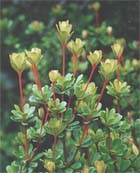
Then came the bamboo segments, where you can see a mixture of thin and fat bamboos and some giant bamboos with the diameter of a football rising up to the sky. It's quite typical of the bamboos collapsing and falling on each other, forming canopy of walkways where you have to bow slightly to get through it, like paying tribute as you enter the land of unexpected beauty and surprises. After the bamboos was the heart of the lowland jungle, where the density of the jungle overwhelms you. Everything is so rich, despite not seeing a single moving creature in sight, it felt like a hustle and bustle there. The big trees are shooting high into the sky, the parasitic plants climbing as enthusiastically towards the sunlight, with big leaves, fully nourished and so many other plants.... shrubs, different kinds of wild orchids blooming cheerfully, the floor laid with crawling rattans, each space is occupied. It felt.... full like not an inch of space is wasted without life. It was quite a long walk through the dense jungle, before we arrived at the first campsite where the sweat bees just won't give up humming beside your ear, and the sand flies....sneaking up to you without warning or signs, only 2 days later manifesting the angry, very very itchy red flares on the arms and legs which I have poured a bottle of eucalyptus oil on them by now. The first campsite was just above the river. It was a perfect place, just for the trees, and me only if agas2 were non-existent.
The second day sees me going through the thick jungle again for another 2 hours, where most of the huge trunks of fallen trees form part of the scenery. Sitting across them is the usual trick to get over them. The river water gets clearer and clearer and more and more beautiful as the altitude gets higher and deeper into the forest. Sounds of the running water calms as we enter into the last water point before the steep 2 hours climb to the peak. We had to harvest water at the last water point to prepare for the overnight stay at the peak. That, I was sure, the water there had no contamination from human excretion. This is the first time that I didn't get diarrhoea from drinking water straight from a stream. The climb to the peak was TOUGH. It was drizzling on and off, mud was the description for the terrain, and lots and lots of tree roots crossing above and below, creating a lot of tight spaces where we had to squeeze through with our huge bags and tents. There were stops where I had to look carefully for the trail markings as I was walking alone most of the time, and lovely Robbins and birds flew past me, stopped in front of me, we checked each other out before it took off again to look for food. As the weather gets colder, I was relieved, as cooler temperature ensures longer endurance, I MUST SUSTAIN TO THE PEAK. That was the only thought I had. When I reached the peak, the sunlight was greeting me from above. Reaching the sunshine from the mossy forest below is like coming to a heavenly sight. My attires were already soaked in mud and dirt, nails lined with black dirt and expected to stay for another 2 days since there will no cleaning up at the peak. We watched a magnificent sun rise from the peak....I held my breath when the sun was slowly but unwittingly rising, the horizon reminds me there is much awaiting for me in life. Decisions in life would be made and not regretted later, with such enlightening sight. Journey down later was like watching the movie again, from the end to the beginning. With newly made friends and lots of enthusiasm to return to civilisation, the journey seemed shorter than expected. The sightings of possibly panther paws followed by sights of Orang Asli3 carrying the bamboo and rattan out into the village from the jungle indicated we were near the exit. The last river, rumbling unforgiving in colours of red clay a.k.a. Teh Tarik kao, is the indicator of human activities, where the water of crystal clear origin was mixed with mud from the landslides and erosions secondary to logging activities.
The end is this write up, one hand scratching and another typing ...arrrgh!!
Do email back and tell me if you read this email completely, haha!!!
Author: TAN KENG LU
Date: 5 April 2007
Email: kenglu@yahoo.com
Notes:
1 Mountains in Peninsular Malaysia with altitude exceeding 7,000 ft
2 Sand flies
3 Natives
The author was in an expedition of 12 hikers to Mt. Yong Yap via Pos Brooke from 31 March 2007 to 2 April 2007.
Edited by: LIM FANG HAU
Date: 11 April 2007
For more photos on the Mt. Yong Yap expedition do visit this link at http://fhlim.multiply.com/
Labels: mtyongyap
 Malaysia. The area around Gunung Yong Yap, Sungai Siput, is notorious for it's tigers, who have already killed many villagers around there. The trek up and down Gunung Yong Yap can be done comfortably in 3 days. The trek used to be untouched all the way to the mountain peak, but now, there are many parts where the trek crosses a logging road. Trees which have been marked for felling can also be seen along the trek. I believe the logging activities will creep closer - closer to the mountain , and one day, perhaps we can drive up Gunung Yong Yap. This mountain is rather expensive because of the cost of transport from Lasah town to Kuala Mu, where the trek begins. First, you have
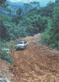 to get a train or bus to Sungai Siput, Perak. Then you have to board a local bus to Lasah town, a small village. There, you have to leave your name and expected time out at the police station. You will also board the 4WD at Lasah. The 4WD ride has to booked in advance and costs quite a lot, around RM500.00 each to and fro, with a maximum capacity of about 7-8 persons. Guides can be obtained on the spot at Kuala Mu, and they charge about RM30.00 per day per guide.
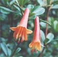 starts at a small waterfall across the river. The trek is rather steep at the beginning but slowly lessens. The trek then meets up with the logging road, and you will have to walk along the logging road for quite some distance. The trek then continues into the jungle and crosses the logging road a few more times. The first campsite has a dilapidated hut built by the orang asli, and there is an abandoned tapioca plantation nearby. There is also a small river about 2 meters wide for washing and bathing.
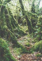 hike to the next campsite, where the last water point is , is about 1 hr away. This part is not very steep. To save time, fill up your water bottles for the night at the peak at the first campsite. This way, you don't have to stop many times and waste time. From the second campsite, it is about another 6 hours to the peak. The trek is steep, and there are
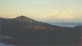 parts where you'll be sliding down !!!! The last water point is about 1 - 1.5 hours from the peak, towards the right. The water point is not very visible and you should make sure someone knows where it is. There is a small rocky stream at the water point, about 10 minutes down from the main trek. The peak is rather big, capable of fitting about 10 - 15 tents. The view from the peak is also number one, because you can see the whole
 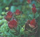 fetch you in the evening, it would be a better if you spent the night at the first campsite. This is because if you spend the night at Kuala Mu , the orang asli children will crowd around you and watch every single thing you do. You may find it amusing in the beginning, but believe me, after about 4-5 hours, it'll get annoying. Another reason is that the orang asli at Kuala Mu rare dogs, which some Muslims might find rather unpleasant. If you spend the night at camp one, Kuala Mu can be reached in about 2-3 hours, just in time for lunch ,a quick dip and some shopping (blow pipes, fish traps, durians..... etc etc) before taking the 4WD out.

